
For this year’s 46th Annual Summer School of the Society of Cartographers I recalled the making of the World Population Atlas and wrapped all material up for some contributions for the meeting. The outcome are two new posters and a presentation for the delegate’s session:
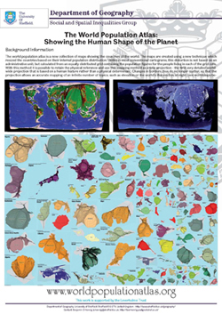 Poster: The World Population Atlas |
 Poster: Creating Gridded Cartograms |
The content on this page has been created by Benjamin Hennig. Please contact me for further details on the terms of use.