Geovisualisierung im Zeitalter der Globalisierung

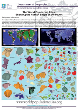
Unlike the post-apocalyptic scenario in infamous Waterworld, what would a world without oceans look like? An oceanless world, so to say, but not like one of the supercontinents that we already had. Instead, more like our today’s continents in the shape of the living space of humankind. In the digital era of cartography, this kind of map is just a few clicks (and much processing time) away, and results in this map curiosity: The image of the world as an oceanless population planet:

gridded population cartogram of an oceanless world
(click for larger version)

The map has been presented first at my talk for the DGfK‘s (German Cartographic Society) colloquium at the University of Applied Sciences in Karlsruhe (a German summary can be found here). In 2013 it has been published as a E&P A feature (see here).
As it was all about visualisation (and maps, of course), I used the Prezi presentation tool to visualise this talk. Here it is:

Continue reading

Gridded Cartograms and the World Population Atlas

For this year’s 46th Annual Summer School of the Society of Cartographers I recalled the making of the World Population Atlas and wrapped all material up for some contributions for the meeting. The outcome are two new posters and a presentation for the delegate’s session:

The World Population Atlas: Showing the Human Shape of the Planet
Poster: The World Population Atlas
Poster: Gridded Population Cartograms: Drawing the Human Shape of the Planet
Poster: Creating Gridded Cartograms

The content on this page has been created by Benjamin Hennig. Please contact me for further details on the terms of use.

The Real World at Night

The night view of the earth has become a very popular depiction of this planet. Although the NASA itself says that “The brightest areas of the Earth are the most urbanized, but not necessarily the most populated” many people mistake this view as a representation of the inhabited places on the globe. Our gridded population cartogram can help to get a better understanding of the relation of people and light. The following map is a reprojection of the earth at night that shows the nightview in relation to the population distribution. The gridlines are kept in a light colour and thus allow to identify those areas where the lines converge (representing the unpopulated regions). In contrast, the populated areas are given the most space, so that one can easily see which populated areas are literally illuminated at night – and where there are people living in darkness. The resulting map is an impressive picture of an unequal world, with large parts of Africa living in darkness, and the affluent countries in Europe and North America glowing in the dark:

The Earth at Night projected on a gridded population cartogram(click for large image)
See here for an updated and more detailed version of this map

Continue reading

A population-centric map projection

Here is some material from a presentation at this year’s  AAG Annual Conference in Washington DC. The presentation People powered maps: A population-centric map projection was given in the session on Topics in GIS, Remote Sensing, and Spatial Analysis and showed some new works on our grid-based cartograms (as presented at GISRUK 2009 and ESRI UC 2009).
The following animation shows the transformation of a topographic map of the United States, ending in a grid-based population cartogram (and then reversing). Please notice that loading the animation takes a while on slower internet connections:

USA Animated Population Cartogram with Topography
(click for larger view)

This is the full presentation given at the AAG Meeting. Please note that the animated parts such as the above animation are not shown in this Slideshare version:

The content on this page has been created by Benjamin Hennig. Please contact me for further details on the terms of use.

ArcUser article: Re-Mapping the World’s Population

My contribution to the ESRI UC 2009 found its way into the Winter 2010 edition of ArcUser:

  • Hennig, B.D., Pritchard, J., Ramsden, M., and Dorling, D. (2010). Remapping the World’s Population. Visualizing data using cartograms. ArcUser 2010 (1), 66-69.
    pdf icon Article as PDF ; Article online
  • The slideshow from last year’s talk at the ESRI UC Is now also available online to watch on Slideshare:

    The content on this page has been created by Benjamin Hennig. Please contact me for further details on the terms of use.

    Gridded cartogram tutorial

    This is a short slideshow showing the basic steps that are needed to do your own gridded population cartograms (with a quite rough 1 degree grid – good for starting with this whole thing). Software needed for this simple click-through tutorial are ArcGIS and ScapeToad. If you want to go one step further, I’d recommend using the ArcScript Cartogram Geoprocessing Tool by Tom Gross, even though this is not featured in this demo:

    The tutorial was given in October 2009 to students of the Module GEO6016 Data, Visualisation and GIS in the MSc in Social and Spatial Inequalities at the University of Sheffield.

    The content on this page has been created by Benjamin Hennig. Please contact me for further details on the terms of use.